Backpacking Panther Creek

one_shot_no_mor

Senior Member
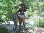
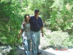
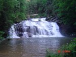
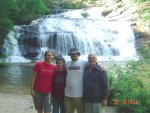
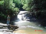
Here are a few photos from backpacking Panther Creek to the falls a couple of weeks ago. Me, my son, and grandson hiked in on a Friday and came back out on Sunday. My daughter joined us for a day. We had a BLAST!! I'm slow in posting pictures due to recovery time...:banginghe
My 42 pound pack WILL be lighter next time!!:bounce:
 

Attachments

  • DSC07034.jpg
    DSC07034.jpg
    222 KB · Views: 788
  • DSC07035.jpg
    DSC07035.jpg
    213.3 KB · Views: 804
  • DSC07041.jpg
    DSC07041.jpg
    138.8 KB · Views: 817
  • DSC07042.jpg
    DSC07042.jpg
    103.1 KB · Views: 797
  • DSC07051.jpg
    DSC07051.jpg
    119.6 KB · Views: 811
  • DSC07057.jpg
    DSC07057.jpg
    181.3 KB · Views: 838

KDarsey

Senior Member
That is better than Great!
I know you enjoyed that especially the company you had!
 

backwoodsjoe

Senior Member
Great photos and looks like ya'll had a great time. I enjoy doing that myself. Thanks for sharing your adventure with us !:
:cool:
 

Nicodemus

The Recluse
Staff member
Mighty purty place!!
 

Paymaster

Old Worn Out Mod
Staff member
Great Pics!
 

jonkayak

Senior Member
I have swam at the bottom of the big falls on many hot summer days. It's one of my Favorite trails in the whole state. Glade to see you enjoyed yourself.
 
Yep, great pics. Great place. Not too far up the road from me, been there many times.

Some future trip try the Falls Hike from the bottom end. The bottom end is in Stephens County with the trail end coming out near Yonah Dam. From this end, it is only 1/3rd the distance to the falls opposed to walking from the Hwy 441 trail end. Much different and varied scenery. You do have to walk over a mountain to get there from this end...but on the way back you're walking down the mountain. I always would go that way now.

Have fun!
 

one_shot_no_mor

Senior Member
Yep, great pics. Great place. Not too far up the road from me, been there many times.

Some future trip try the Falls Hike from the bottom end. The bottom end is in Stephens County with the trail end coming out near Yonah Dam. From this end, it is only 1/3rd the distance to the falls opposed to walking from the Hwy 441 trail end. Much different and varied scenery. You do have to walk over a mountain to get there from this end...but on the way back you're walking down the mountain. I always would go that way now.

Have fun!

Any good campsites coming in from that direction? Where is the trail head?
 

Win270Brown

Senior Member
Beautiful place. I've camped there once before. I came in from the dirt road side, and met with a group that had hiked in from the Yonah Dam side. They said it was a rough hike up the mountain, but well worth the scenery.
 
Any good campsites coming in from that direction? Where is the trail head?


Hey there, Here's the directions. Look at it on a street map also to confirm your bearings.

From downtown Toccoa, go north on Prather Bridge road....and just keep on going. It'll be about 10 miles or so. You'll eventually see the Savannah River on your right. This is the headwaters of the Savannah River as it comes out of Yonah Dam from Yonah Lake.

You'll pass the entrance to the Ga. Power Dam Facility on your right. Keep going straight on the paved road. In about another mile or so you'll see a road Vee off to the left. This is Panter Creek road, dirt road. 1 block in you'll pass an old church on the right. Follow this road until it dead ends in a circular dirt parking area. This is the Trail End, There is a nice new bridge across the creek. Cross the bridge and the trail goes up the west side of the creek.

Camping? There are many several campsites along Panther Creek along the way on the road as you drive in. The road follows Panther Creek most of the way.

Camping on the trail will be strictly primitive/backpacking.

The bottom end of the trail USED to go up the right hand or east side of the creek for about 1/4 mile and then crossed a bridge and continued on up the west side of the creek. That bridge washed away many years ago but the trail is still there. You can walk a good bit of gear up this trail a relatively short way from the parking area and there is a nice island in the middle of the creek and folks camp there. Fishermen also use this old east-side trail to walk up the creek to fish.

I haven't done it yet, but a real awesome adventure would be to walk up the creek itself this way all the way to the falls. Is essentially wilderness. There is some trail here and there, mostly walking rock to rock and then through the water where you have to.

This is cool as the regular trail on the bottom end is only along the creek for about 25% of it's length to the falls. As stated in earlier replies, the trail turns and goes over a mountain as a "shortcut." So you're well above and away from the creek on this longer portion. So there is this very long stretch of creek that is out of view and no one travels it.


Enjoy!
 

guitarzan

Member
One of my favorite trails, not too long, not to short, not too hard for beginners, but not too easy either. And you have those beautiful falls to look forward to.
 

greene_dawg

Senior Member
Great trail, a little overused but still a great place. Where is the last falls in the pics? Downstream of the big falls???
 

one_shot_no_mor

Senior Member
Great trail, a little overused but still a great place. Where is the last falls in the pics? Downstream of the big falls???
Upstream...just at the top of the main falls. I was looking upstream to take a picture of my grandson. If I turned around from where I was standing, I would have been looking down on the camping area at the bottom of the falls.:D
 
Top