Yep, for the East Coast anyways. You need to have Google Earth downloaded on your computer first. Go to the Bay Survey page on Michael Davias' website and click the quadrant you want to look at. Click on the DEM Link when it comes up and it should overlay it straight to your Google Earth.
Careful...it's addicting! I can look at those images all day!
I just updated the original post with Part 6 of my presentation on Carolina Bays. This one is on the Black Mat layer found at many of the Clovis cites around the country as well as the work of the Comet Research Group. Enjoy!
Thanks for watching and I'm glad you're enjoying them. Although, I'm surprised there hasn't been more interest here on the GON forum, being that most people here are hunting and fishing in areas directly impacted (no pun intended) by this event.
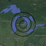
Very interesting videos,,,, being from MI makes it even more so,,,, do you think the impact helped to form Saginaw Bay? Or was it strictly from the glacial retreat? Great fishing in the bay BTW,,,,
Very interesting videos,,,, being from MI makes it even more so,,,, do you think the impact helped to form Saginaw Bay? Or was it strictly from the glacial retreat? Great fishing in the bay BTW,,,,
Yes, I think the impact created Saginaw Bay with the deepest part of Lake Huron, which is in line with the Bay, being the bottom of the creator. I also think the immediate melting of the glacial ice and the torrential flooding that would have occurred immediately afterwards probably helped shape the Great lakes as we see them today. I'll admit, however, I'm not super familiar with the Great Lakes area, so much of this is speculation. Makes sense to me though...
Yes, I think the impact created Saginaw Bay with the deepest part of Lake Huron, which is in line with the Bay, being the bottom of the creator. I also think the immediate melting of the glacial ice and the torrential flooding that would have occurred immediately afterwards probably helped shape the Great lakes as we see them today. I'll admit, however, I'm not super familiar with the Great Lakes area, so much of this is speculation. Makes sense to me though...
For anyone following along with the Carolina Bay Saga, I encourage you to check out the work of Antonio Zamora. I mention him a few times in my series and really do think he has this figured out. He's written a few books and scientifically reviewed journal articles on the subject, and has recently started to step up his YouTube game. Here's his most recent addition:
Here's my most recent addition to my presentation on the formation of the Carolina Bays. Connecting the dots between the Carolina Bays and the great megafloods of North America!
I'm curious, has anyone used the Lidar Images from Cintos.org's Bay Survey to identify any Carolina Bays on your property? It might come in handy to know where some of them are as I change gears to take a more scientific approach to this thing in the coming months!
All you need to view these overlays is the free Google Earth "Pro" downloaded to your computer. Shoot me a PM if you need a hand.
We as a society are stupid and that is world wide. I believe the aboriginal people left in this world understand all the things you speak of and probably have stories from that time period that most scientists dismiss because the scientists can’t take the credit for discovering these tribal stories and beliefs. Changes are still taking place but not at the magnitude of those you are speaking of or we don’t recognize those changes because most people live in an artificial world separated from nature.
Jeff