DDD
Winter Weatherman
Alright, much has been made about the upcoming winter weather threat that is possible here in Georgia as well as Alabama, South Carolina and North Carolina. There are maps flying all over social media and I wanted to try and bring some focus into what is being shown and what I think is reality or possible.
Let's get the obvious out of the way. The NAM modeling brings the most precip to the most areas, the EURO took a step towards the NAM this afternoon with broader coverage but the precip is light. The GFS is only rain and dry conditions. That's where we are at.
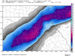
That said, I for one don't think we are going to have moisture issues. The front that comes across is VERY positively titled. As it gets draped across the deep south it allows moisture to come riding "back over" into what is now air that is at the surface and vertically somewhere around 32-34 degrees. The issue will be what kind of moisture will be falling out of the sky. These clown maps show how much snow it thinks is accumulating which is nothing more than what it sees falling out of the sky.
Some years back we had an Upper Level Low that rolled through here. At my house in Dacula it snowed like crazy but there was mixing issues and the rate was on and off. Over in Athens... maybe 25 miles the way the crow flies, they had 8" of heavy wet snow that brought down tree limbs. The rate was faster and the moisture was heavier. That is what it will take to get accumulating snow here this week. A heavy rate of snow.
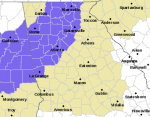
Right now to me, a line from Columbus to Macon over to Augusta northward to a line about Cedartown to Canton to Helen should see a flakes fly. You may even see a lot of flakes fly but just not accumulate.
I am going to attach some clown maps. This is not a forecast or even anything I am buying into just yet. The spread on models is from 0 anywhere to 3" in Columbus. Pick what you like. Yesterday the NAM had 8" in Columbus.
I will attempt to post another update in 24 hours.
Last, this forecast is a tough one. The time of the year is all wrong, the modeling is all over the place, the long positively tilted front stretched out like it is modeled is tough to predict how the moisture out of the gulf will interact with it.
Just like always, need more time and more model runs. The last NAM run is a dream come true for South GA folks.
More to come later.
Let's get the obvious out of the way. The NAM modeling brings the most precip to the most areas, the EURO took a step towards the NAM this afternoon with broader coverage but the precip is light. The GFS is only rain and dry conditions. That's where we are at.
That said, I for one don't think we are going to have moisture issues. The front that comes across is VERY positively titled. As it gets draped across the deep south it allows moisture to come riding "back over" into what is now air that is at the surface and vertically somewhere around 32-34 degrees. The issue will be what kind of moisture will be falling out of the sky. These clown maps show how much snow it thinks is accumulating which is nothing more than what it sees falling out of the sky.
Some years back we had an Upper Level Low that rolled through here. At my house in Dacula it snowed like crazy but there was mixing issues and the rate was on and off. Over in Athens... maybe 25 miles the way the crow flies, they had 8" of heavy wet snow that brought down tree limbs. The rate was faster and the moisture was heavier. That is what it will take to get accumulating snow here this week. A heavy rate of snow.
Right now to me, a line from Columbus to Macon over to Augusta northward to a line about Cedartown to Canton to Helen should see a flakes fly. You may even see a lot of flakes fly but just not accumulate.
I am going to attach some clown maps. This is not a forecast or even anything I am buying into just yet. The spread on models is from 0 anywhere to 3" in Columbus. Pick what you like. Yesterday the NAM had 8" in Columbus.
I will attempt to post another update in 24 hours.
Last, this forecast is a tough one. The time of the year is all wrong, the modeling is all over the place, the long positively tilted front stretched out like it is modeled is tough to predict how the moisture out of the gulf will interact with it.
Just like always, need more time and more model runs. The last NAM run is a dream come true for South GA folks.
More to come later.