For grins and giggles only mind you, this is not the NWS's opinion and only a guess from me based on what I've been seeing on the models for a few days, and the fact that it is getting better, not getting weaker and going away, yet.
DAY 4-8 CONVECTIVE OUTLOOK CORR 1
NWS STORM PREDICTION CENTER NORMAN OK
0406 AM CST WED JAN 27 2016
VALID 301200Z - 041200Z
CORRECTED FOR WORDING IN SECOND PARAGRAPH
...DISCUSSION...
THE MEDIUM-RANGE MODELS CONTINUE TO INDICATE THAT A STRONG
MID-LATITUDE SHORT WAVE TROUGH WILL DIG INLAND ACROSS THE CALIFORNIA
COAST LATE THIS COMING WEEKEND...AND RAPIDLY THROUGH THE FOUR
CORNERS REGION BY EARLY MONDAY. DIFFERENCES BETWEEN THE ECENS AND
NCEP MREF THEN SLOWLY BEGIN TO INCREASE CONCERNING THE SPEED OF
FORWARD PROGRESS...EASTWARD ACROSS THE CENTRAL/SOUTHERN
ROCKIES...AND NORTHEASTWARD THROUGH THE MISSISSIPPI VALLEY BY THE
MIDDLE OF NEXT WEEK. HOWEVER...AGREEMENT EXISTS CONCERNING SUPPORT
FOR STRONG SURFACE CYCLOGENESIS FROM THE SOUTH CENTRAL PLAINS
THROUGH THE LOWER OHIO VALLEY. AND IT APPEARS PROBABLE THAT A
SUBSTANTIVE RETURN FLOW OF MOISTURE FROM THE GULF OF MEXICO INTO THE
WARM SECTOR OF THE LOW WILL EVENTUALLY SUPPORT A CONSIDERABLE
INCREASE IN POTENTIAL FOR SEVERE STORM DEVELOPMENT...IN THE PRESENCE
OF STRONG VERTICAL SHEAR.
GUIDANCE IS SUGGESTIVE THAT A 100 KT WESTERLY JET STREAK AT 500 MB
WILL ACCOMPANY THE UPPER SYSTEM...WITH A 50-70 KT SOUTHERLY JET AT
850 MB DEVELOPING BY NEXT TUESDAY ACROSS THE LOWER MISSISSIPPI
VALLEY. DIFFERENTIAL THERMAL ADVECTION AND STRONG FORCING FOR
UPWARD VERTICAL MOTION MAY SUPPORT INCREASING POTENTIAL FOR SEVERE
STORMS ACROSS PARTS OF THE SOUTH CENTRAL PLAINS INTO THE ARKLATEX
AND OZARK PLATEAU AS EARLY AS MONDAY NIGHT. HOWEVER...CONFIDENCE IN
SUBSTANTIVE LOW-LEVEL MOISTURE RETURN /SURFACE DEW POINTS INCREASING
THROUGH THE 60S...PRECIPITABLE WATER INCREASING UP TO 1.25 INCHES/
AND BOUNDARY LAYER DESTABILIZATION IS GREATER ON TUESDAY ACROSS THE
LOWER MISSISSIPPI VALLEY. SEVERE STORM DEVELOPMENT AS FAR NORTH AS
THE MIDDLE MISSISSIPPI AND LOWER OHIO VALLEYS DOES NOT APPEAR OUT OF
THE QUESTION BY TUESDAY...AND EASTWARD TOWARD THE APPALACHIANS AND
SOUTHEAST NEXT WEDNESDAY...BUT LOWER CONFIDENCE PRECLUDES 15 PERCENT
SEVERE PROBABILITIES ACROSS THESE AREAS AT THIS TIME.
1 week chasing winter weather the next week severe weather and then by Feb. 10 we will be back on the chase for Winter weather once again ?
I will say for my neck of the woods in Feb. 21 93' Cedartown, Ga got nailed by a Tornado and then less then a month later the Blizzard so maybe history repeats all though I can do without spin ups...
Soon Grasshopper, very soon. This evenings GFS run returned much stronger than this mornings. Dissipation before our neck of the woods is a relative term. How many relatives you got?
1 week chasing winter weather the next week severe weather and then by Feb. 10 we will be back on the chase for Winter weather once again ?
I will say for my neck of the woods in Feb. 21 93' Cedartown, Ga got nailed by a Tornado and then less then a month later the Blizzard so maybe history repeats all though I can do without spin ups...
I certainly wouldn't count it out, but the long range (through late April) outlook is overall a warming trend with differential temps as high as 15°F+ over norm.
It could very well be an active spinny thing season. We haven't had a good one in quite a while.
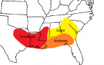
The NWS doesn't seem to want to elevate or expand the conv. poss. percentage area east any. Currently it covers the ArkLaTex area and MS & AL. Give em a day or two more. They'll see the light.
Seriously though, the LI numbers in MS & AL on the current GFS is -5, that is a tremendous amount of instability, and for the ArkLaTex area it is -4, still plenty of instability to make spinny things.
But take heart, yesterday they only had it in the Bama area, contrary to my pseudo effected areas map. Like I said, give em time. The values on every run keep getting stronger and stronger.
It's been many years since we've had a volatile spinny thing season. This just might be our year.