DDD
Winter Weatherman
Wow. Just wow.
What else can I say? While this storm did not blanket everyone in North Georgia it covered a lot of folks from one end of the state to the other running right along Interstate 85. Everyone North or North West of 85 saw snow of some accumulation. Yes, it varied. I am south of 85 and ended up with just under 2". However most folks that really cashed in with big snow numbers are North and NW of 85. This is probably the biggest snow since 1993.
I have seen some big totals. 10-13" in some isolated places.
All that said, what did I or what did we learn? I think many things in retrospect.
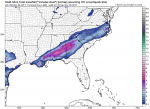
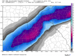
The NAM-WRF (long range NAM) and the Canadian model smelled this thing coming from a long ways out. The NAM was too far south, but when the Canadian got a hold of it, it started to take it more NW and with each run the NAM started to come North with it's solution. I will post pics showing what I am talking about.
Also, much was discussed on TV and radio about ground temps being too warm and road temps being to warm to sustain accumulations on roads. Clearly, clearly this storm has thumbed it's nose in the face of those outlooks / forecast. People in the south don't have a lot of experience with BIG snow events. Not only big snow events but heavy snow rates. I read and listened to folks who do have said experience talk about how soil and road temps don't mean a thing if high snowfall rates are achieved. I too listened and didn't believe it. I am a believer now.
I started seeing reports Friday morning, first one I remember was from Tallapoosa and the road was covered. I immediately thought... uh oh. Then I heard WSB report that I-75 in Bartow county was collecting snow. Real big uh-oh. Then I got tweets and messages 3" in Blairsville. A friend of mine in Dawsonville texted me, "Dude.. there is snow in the road here and its piling up on my deck..." Uh-oh. Yeah... surprise. Then I hear Kirk Melish say it's "over performing". Coming from him... that's a red flag. This thing is amped up.
I was driving back from deer hunting East of Athens in Madison County about noon on Friday. Listening to the radio, phone buzzing, friends calling, friend of mine who is on here texted me with a picture of a big buck his son killed in the snow in Jackson County... As I drove and listened to WSB talk about road conditions completely hosed, schools cancelling, videos of school buses in Paulding that couldn't make it up hills... I realized mother nature does what she wants.
As is with any storm when you look back at model data, you realize the answers were there, you just have to have some experience and filter out what is right and what is wrong. If you follow me on Twitter you may have seen one of our local Mets on TV who tried to tell me the GFS was glitchy and unreliable, the NAM-WRF was not reliable outside of 24 hours and what the EURO snow map was cranking out was not true.
 Funny... the NAM nailed this storm minus that it was too far south early but corrected North inside of 48 hours. When I made my call map it was mainly based on the NAM however I backed off of totals because I felt like the soil temps would affect the totals. I was too far south in my thinking because I was hugging the NAM. I should have known it would come North or NW. It always does. Those that follow me know I always say, it's going to come NW... not sure why I didn't take my own advice. Note to self... it will come NW. Also, as stated, high snow rates don't care about your soil or road temps.
I realized with this storm that I have gotten too conservative. I have done so because others who have come after me have made a bad name for shade tree weather junkies like myself. Scaring people into thinking bad weather is coming and causing them to buy bread and milk for no good reason. I am going to try and break out of that mold and just report. You decide if you need to prepare or not. Weather is not an exact science and weather people need to quit acting like it is. It's not.
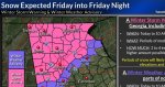
That said, in the first picture you will see the NAM from Tuesday, second picture is the NAM from Wednesday, third picture is the Canadian on Wednesday, fourth picture was the final Winter Storm Warnings and Advisories from the NWS and the last is the snow total observations as reported by the NWS. I post the Warning and Advisory pic for reference. Winter Storm Warnings are rare and this one needed it. The last pic was for reference as well.
What else can I say? While this storm did not blanket everyone in North Georgia it covered a lot of folks from one end of the state to the other running right along Interstate 85. Everyone North or North West of 85 saw snow of some accumulation. Yes, it varied. I am south of 85 and ended up with just under 2". However most folks that really cashed in with big snow numbers are North and NW of 85. This is probably the biggest snow since 1993.
I have seen some big totals. 10-13" in some isolated places.
All that said, what did I or what did we learn? I think many things in retrospect.
The NAM-WRF (long range NAM) and the Canadian model smelled this thing coming from a long ways out. The NAM was too far south, but when the Canadian got a hold of it, it started to take it more NW and with each run the NAM started to come North with it's solution. I will post pics showing what I am talking about.
Also, much was discussed on TV and radio about ground temps being too warm and road temps being to warm to sustain accumulations on roads. Clearly, clearly this storm has thumbed it's nose in the face of those outlooks / forecast. People in the south don't have a lot of experience with BIG snow events. Not only big snow events but heavy snow rates. I read and listened to folks who do have said experience talk about how soil and road temps don't mean a thing if high snowfall rates are achieved. I too listened and didn't believe it. I am a believer now.
I started seeing reports Friday morning, first one I remember was from Tallapoosa and the road was covered. I immediately thought... uh oh. Then I heard WSB report that I-75 in Bartow county was collecting snow. Real big uh-oh. Then I got tweets and messages 3" in Blairsville. A friend of mine in Dawsonville texted me, "Dude.. there is snow in the road here and its piling up on my deck..." Uh-oh. Yeah... surprise. Then I hear Kirk Melish say it's "over performing". Coming from him... that's a red flag. This thing is amped up.
I was driving back from deer hunting East of Athens in Madison County about noon on Friday. Listening to the radio, phone buzzing, friends calling, friend of mine who is on here texted me with a picture of a big buck his son killed in the snow in Jackson County... As I drove and listened to WSB talk about road conditions completely hosed, schools cancelling, videos of school buses in Paulding that couldn't make it up hills... I realized mother nature does what she wants.
As is with any storm when you look back at model data, you realize the answers were there, you just have to have some experience and filter out what is right and what is wrong. If you follow me on Twitter you may have seen one of our local Mets on TV who tried to tell me the GFS was glitchy and unreliable, the NAM-WRF was not reliable outside of 24 hours and what the EURO snow map was cranking out was not true.
Funny... the NAM nailed this storm minus that it was too far south early but corrected North inside of 48 hours. When I made my call map it was mainly based on the NAM however I backed off of totals because I felt like the soil temps would affect the totals. I was too far south in my thinking because I was hugging the NAM. I should have known it would come North or NW. It always does. Those that follow me know I always say, it's going to come NW... not sure why I didn't take my own advice. Note to self... it will come NW. Also, as stated, high snow rates don't care about your soil or road temps.I realized with this storm that I have gotten too conservative. I have done so because others who have come after me have made a bad name for shade tree weather junkies like myself. Scaring people into thinking bad weather is coming and causing them to buy bread and milk for no good reason. I am going to try and break out of that mold and just report. You decide if you need to prepare or not. Weather is not an exact science and weather people need to quit acting like it is. It's not.
That said, in the first picture you will see the NAM from Tuesday, second picture is the NAM from Wednesday, third picture is the Canadian on Wednesday, fourth picture was the final Winter Storm Warnings and Advisories from the NWS and the last is the snow total observations as reported by the NWS. I post the Warning and Advisory pic for reference. Winter Storm Warnings are rare and this one needed it. The last pic was for reference as well.