DDD
Winter Weatherman
Well, I hope you guys and gals have enjoyed the chase. Today the chase ends and the reality begins. I have changed my thinking a little given short range modeling. Just like the global models, the short range models are all over the place, so you have to take a blend of those and what is happening and make an educated guess.
So let's get right into it.
I cannot stress this enough. There is going to be a serious line between ALL SNOW, Snow and sleet mixed together, ALL SLEET, Freezing Rain and Sleet, All Freezing Rain and Rain. Got all that? LOL
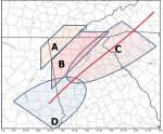
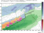
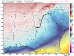
I have made a last call map. I think the I-85 corridor is going to be sort of the fall line. 50 miles north or 50 miles south of I-85 is going to be where the heartbreak (if you want snow) and the magic will happen.
I could see a scenario (just an example) where Buford is shoveling 5" of snow and Dacula only has 2". There is not one MET or anyone that I know that can tell you where that line will be. Complete guess work.
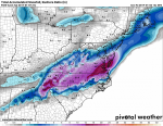
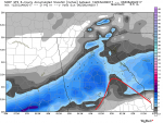
There is a warm layer of air that keeps making the mixing issues a problem. If that warm layer is stronger, this will have a hard time being much of anything, however if that warm layer is not as strong as some models have, it will be more snow.
Also, it's worth noting that some modeling thinks we will have trouble switching over to much of anything at all. So much uncertainty.
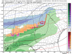
So here we go:
A: What falls here will be all snow. Temps and atmosphere layers will be plenty cold. Problem here is lack of precip. I think when it's all said and done, this area may end up with 1-2" of snow.
B: Going West to North East the snow will go from light to heavier as you move into the foothills of the Appalachians and into the mountains. The farther North and East you go in this area the higher the totals. This area should be 1-5" going from that West to to NE direction.
C: This area is going to be the Fail / Win zone. There is just no other way to put it. This area stands the best chances at scoring a large amount of snow and a large amount of rain. Just no way to sugar coat it. This area could also become one heck of a sleet storm if the warm air aloft does not bend. This area has the potential to be 1-6" of snow, 3" of sleet, .10" of freezing rain and all of the above. It simply is going to be the battle ground. The silver lining of this area is that whoever is on the snow side of this area is going to be the envy of snow lovers in the state of GA.
D: This area has become concerning for sleet / freezing rain only due to thermal issues. This area needs to be more concerned about ice and freezing rain than snow totals.
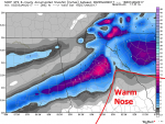
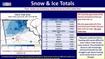
UPDATE: Just as I am typing this, 12Z short range modeling and GFS continue to inch up the warm layer and warm nose Northward. NE GA mountains would have almost a foot of snow and that area won't have mixing issues. This will rob many, including the Metro Atlanta area of heavier snow totals. Not saying it will happen, I am just telling you how it looks. If the trend continues NW, Atlanta will be out of the game.
Anyone have a cliff I can jump off of?
So let's get right into it.
I cannot stress this enough. There is going to be a serious line between ALL SNOW, Snow and sleet mixed together, ALL SLEET, Freezing Rain and Sleet, All Freezing Rain and Rain. Got all that? LOL
I have made a last call map. I think the I-85 corridor is going to be sort of the fall line. 50 miles north or 50 miles south of I-85 is going to be where the heartbreak (if you want snow) and the magic will happen.
I could see a scenario (just an example) where Buford is shoveling 5" of snow and Dacula only has 2". There is not one MET or anyone that I know that can tell you where that line will be. Complete guess work.
There is a warm layer of air that keeps making the mixing issues a problem. If that warm layer is stronger, this will have a hard time being much of anything, however if that warm layer is not as strong as some models have, it will be more snow.
Also, it's worth noting that some modeling thinks we will have trouble switching over to much of anything at all. So much uncertainty.
So here we go:
A: What falls here will be all snow. Temps and atmosphere layers will be plenty cold. Problem here is lack of precip. I think when it's all said and done, this area may end up with 1-2" of snow.
B: Going West to North East the snow will go from light to heavier as you move into the foothills of the Appalachians and into the mountains. The farther North and East you go in this area the higher the totals. This area should be 1-5" going from that West to to NE direction.
C: This area is going to be the Fail / Win zone. There is just no other way to put it. This area stands the best chances at scoring a large amount of snow and a large amount of rain. Just no way to sugar coat it. This area could also become one heck of a sleet storm if the warm air aloft does not bend. This area has the potential to be 1-6" of snow, 3" of sleet, .10" of freezing rain and all of the above. It simply is going to be the battle ground. The silver lining of this area is that whoever is on the snow side of this area is going to be the envy of snow lovers in the state of GA.
D: This area has become concerning for sleet / freezing rain only due to thermal issues. This area needs to be more concerned about ice and freezing rain than snow totals.
UPDATE: Just as I am typing this, 12Z short range modeling and GFS continue to inch up the warm layer and warm nose Northward. NE GA mountains would have almost a foot of snow and that area won't have mixing issues. This will rob many, including the Metro Atlanta area of heavier snow totals. Not saying it will happen, I am just telling you how it looks. If the trend continues NW, Atlanta will be out of the game.
Anyone have a cliff I can jump off of?