***April Severe Weather 2017***

Miguel Cervantes

Jedi Master
Well, not exactly how I wanted to start April off, but tis the season, so here we go.

Monday evening into Tuesday morning early is looking pretty rough so far (hopefully the models will back down)

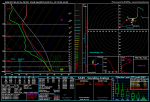
All of the ingredients are coming together for some very bumpy weather. First pic you'll see is the sounding for the map that will follow. Down in the right hand corner you can usually find Severe or Tornado or what is sounding now with the wildly divergent winds at short altitude differences which is PDS Tornado.

We don't see that designation often, and what it means is "Potentially Dangerous Situation / Tornado". This sounding is the same all of the way down the state line from WNW GA to SOWEGA.

Again I'm hoping this lets up and isn't as severe as it is showing now, but now is the time to prepare so I'm putting it out there and have my fingers crossed for a bust.

If this trend continues I will elaborate more. For now the maps should be enough.

040417sndg.png

stp.us_se.png


bs0500.us_se.png


sbli.us_se.png


gfs_mslp_pcpn_frzn_us_13.png
 

Miguel Cervantes

Jedi Master
I was hoping for moderation in this system and am getting none. I still have my fingers crossed for a bust, but it's not looking good.
We've already discussed what a "PDS Tornado" stands for on a sounding. It hasn't gone away like i'd hoped.

This morning's sounding was pulled from the Douglasville area, as well as the 3km helicity map. I left my cursor over the area of concern so it could show the values that indicate critical potential. Anything in the 400-450 range is of concern. Look at the values and you'll see why I'm a fair bit worried about this system.

Also don't think just because the prog'd forecast maps show these values in this area that your area won't be effected. This merely shows how potentially dangerous this system can be.

All of western to the central axis of Georgia should expect high wind gusts, hail, heavy rain and the potential for tornado's. This is looking like an over night storm, aka worst case scenario for those without a NOAA S.A.M.E. capable radio. Even then, your chances are greatly improved but not bomb proof.

Here's some maps:

040217 sndng valid 040417.png

3kmhel val 040317.png

SCC val 040317.png

STC val 040317.png
 

Miguel Cervantes

Jedi Master
Round 2 coming in tomorrow. Expect rain moving into the state as early as 7:00 am-ish and as destabilization increases the severe weather could start ramping up as early as noon and last well into the evening as the cold front approaches us.

We were in the SPC's 35% range for severe weather on Monday, with this system we are in the 45% range and the potential for severe weather is exponentially higher.

The soundings pulled for Monday's event was in the 2500 j kg range and still a PDS Tornado event. Wednesday's soundings are in the 3300 j kg range and start out early in NW GA and W Cent Ga then gradually spread to a larger part of the state as the system nears.

As most learned Monday, and I don't post these warnings lightly, this kind of weather is nothing to play with. A weather siren in your community is not to be relied upon. These tornado's drop fast and often there isn't ample warning to get to safety. A SAME capable weather radio is your best advanced warning in this type situation.

Here are the maps:
 

Attachments

  • 0404sndngvalid040517.png
    0404sndngvalid040517.png
    204.2 KB · Views: 667
  • 04052017bspc.png
    04052017bspc.png
    85.8 KB · Views: 667

Miguel Cervantes

Jedi Master
If we can believe the GFS, it looks like it will be closer to the end of the month before we get another real shot at good rain and severe potential. It looks like a strong low in Texas, combined with the Gulf opening back up for business will be something to watch.

prateptype_cat.conus.png


scp.conus.png


sfct_b.conus.png


850wh.conus.png


500wh.conus.png


500hvv.conus.png


850hvv.conus.png
 

Miguel Cervantes

Jedi Master
Looks like Thursday night into Friday morning could get bumpy according to the Sig Tor parameters.

stp.conus.png


Still too early to nail it down but with the temps we will be seeing this week and an approaching cold front it is well within the realm of possibility.

Looking a couple of weeks out this trend seems to be changing to a 4 to 5 day cycle so tune up your wx radios and get ready for rough weather to return.
 

Miguel Cervantes

Jedi Master
Watching Sunday. If you believe the GFS there won't be much to it. Thing is, I don't use the GFS for spring weather. It is even more unreliable than it is in winter.

I use the NAM and when in range the HRRR.

Looking at different NAM products I am seeing some potential for a severe storm to occur Sunday into Monday coming up.

Here's what I'm looking at. That last thermodynamic map shows the potential for a negatively tilted lps. If this occurs the local mets might start sounding off about this potential sooner than later.

nam_mslp_pcpn_frzn_us_25.png


nam_z700_vort_us_25.png


nam_z500_vort_us_25.png


nam_T850_us_25.png
 

Miguel Cervantes

Jedi Master
Out of curiosity I just pulled a sounding for this next system and my suspicions were correct. There are still a lot of elements that must come together for it to become a severe event, but the potential is there.
 

Attachments

  • sounding for sunday 43017.png
    sounding for sunday 43017.png
    203 KB · Views: 142
Top