Iron-clay rocks, Altamaha grit?

Artfuldodger

Senior Member
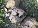
I'm interested in iron or clay rocks that are found in Georgia. Particularly in the Coastal Plain and Piedmont Regions.

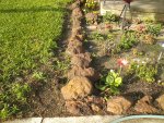
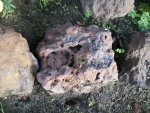
My Dad loaded up a load of these 8-10" large brown iron oxide rocks that occur near the surface near Broxton back in the 50's.
He is not in his right mind enough for me to ask and Mom doesn't remember exactly where he got them. Possibly on Georgia Highway 107 between Jacksonville and Snipesville. Mostly in Coffee County and the Jeff Davis county line.
My brother in law remembers them having to move a lot of rocks when they paved that state road.

Most of the online reports I can find are from the turn of the century. I found one describing these large iron oxide rocks near Broxton and Douglas. also a mention of some smaller iron oxide pebbles the size of buckshot to 4" west of Fitzgerald near the railroad shops.

Many more places were mentionedas well and may be outcroppings of the Altamaha Grit Complex. One of the largest outcroppings of this complex in Coffee County near State Hwy 107 is the Broxton Rocks. It's a pretty popular place to visit as well.
I was thinking that place was mostly limestone or sandstone but my brother in law says there are a lot of iron clay rocks there as well.
 

Artfuldodger

Senior Member
The rocks that I can find online that look the most like these car claystone, mudstone, bog iron, limonite, & clay ironstone.

We always called them iron rocks or clay rocks. They mostly look rust to red colored and some look yellow as well. People say they look like lava rocks as the big ones are full of wholes. Not all of the big rocks have holes in them.

I recently found a small one in Augusta that was full of quarts. A couple of small quarts pieces and a whole layer of quartz sand on the bottom like a conglomerate or breccia.

The small one from Augusta and a some of the big ones from Coffee County;
 

Attachments

  • Augusta2.jpg
    Augusta2.jpg
    289.4 KB · Views: 35
  • 0530180815.jpg
    0530180815.jpg
    644.7 KB · Views: 220
  • 0530180816.jpg
    0530180816.jpg
    448.8 KB · Views: 32
  • 0530180816a.jpg
    0530180816a.jpg
    458.4 KB · Views: 234
Last edited:

Artfuldodger

Senior Member
The large ones from the Broxton, Pridgen, Snipesville area and two small ones from Douglas;
 

Attachments

  • red rock.jpg
    red rock.jpg
    360.3 KB · Views: 14
  • yellow rock.jpg
    yellow rock.jpg
    354.9 KB · Views: 16
  • Douglas2.jpg
    Douglas2.jpg
    192.2 KB · Views: 16

lagrangedave

Gone But Not Forgotten
It’s how they got across the Altamaha before there was a bridge there....when the river is a little low it can be seen, this morning it was submerged....yes at Bullard Creek WMA....
 

Artfuldodger

Senior Member
It’s how they got across the Altamaha before there was a bridge there....when the river is a little low it can be seen, this morning it was submerged....yes at Bullard Creek WMA....

Went over the bridge Friday. Yes the river is a little high. Not in those folks swimming pool yet. My niece was camping a Towns Bluff and we stopped in for a visit.
So is the ford is downstream from Towns Bluff? I guess the rocks were pretty close to the location of the ford. I might have to check it out one day.
 

JustUs4All

Slow Mod
Staff member
Similar rocks can be found in the SE quarter of McDuffie County. The Iron Hill community is located just south of Dearing.
 

Artfuldodger

Senior Member
Similar rocks can be found in the SE quarter of McDuffie County. The Iron Hill community is located just south of Dearing.

Thanks, I didn't know that. I travel down 221 through Wrens quite often. I have noticed Butcher Pen Rd is quite red with clay.

I just googled McDuffie County and found that there is an ironstone outcropping at the fish hatchery which is in the Iron Hill community you mentioned.

Suppose to be some ironstone outcrops in Columbia, Richmond, and Burke counties as well.
 

JustUs4All

Slow Mod
Staff member
We find some smaller similar nodules on my farm just north of Dearing.
 

MOTS

Senior Member
Actually ArtD, you are able to go to the Broxton Rocks now. Google Flat Tub WMA on Google images. It is the one you mentioned in your first post. It was cabled off for many years and finally the state purchased it.
 

Artfuldodger

Senior Member
Actually ArtD, you are able to go to the Broxton Rocks now. Google Flat Tub WMA on Google images. It is the one you mentioned in your first post. It was cabled off for many years and finally the state purchased it.

Yeah I remember it was purchased by the Georgia Nature Conservancy. I was thinking you had to call and visit on a tour or something. Can you just drive down there now?

Back when I was a boy we'd go camping there. Dad took us but quit because kids kept falling in the cracks at night.

Are there any rocks covered in iron or any rocks that look like iron at the Broxton Rocks?

I'm still thinking that area of Coffee County is where my Dad found the rocks for our flower beds.
 

OmenHonkey

I Want Fancy Words TOO !
Ben Hill County has a place called " The Rocks" As well and they are in the north western corner of the county. I believe the paved road that the mud bog place was on is the same road just heading south from the Abbeville side it turns to dirt and the rocks are on the right.
 

Nicodemus

The Recluse
Staff member
There`s ferruginous sandstone scattered from Wheeler County over to the Hooch. I have several chunks of it in my rockpile. I`ll try to get a picture for you.

Just up from the forks of the rivers (Oconee and Ocmulgee at the mouth of the Altamaha) is a stretch called Chaney`s reach on the Oconee. That`s rock through the Reach. Not sure just what kind of rock though, but the channel was blasted way back when. There`s some chert outcrops in Laurens County, and when you get over in lower Crisp, into Lee and Worth, Dougherty, Baker, Mitchell, Grady, and part of Decatur, you`ll find Coastal Plains Chert. In addition to a lot of limestone.
 
Last edited:

Artfuldodger

Senior Member
Ben Hill County has a place called " The Rocks" As well and they are in the north western corner of the county. I believe the paved road that the mud bog place was on is the same road just heading south from the Abbeville side it turns to dirt and the rocks are on the right.

I found this on the "Rocks" in Ben Hill County. May be related to the Rocks in Coffee County. Some believe them to be a meteorite or maybe caused by a meteorite. Seems like that would be easy to prove or disprove.
I think they said that about the one in Coffee County is because of all the big cracks. Like it broke up when it hit the earth.

https://vanishingsouthgeorgia.com/2015/11/27/reubin-lake-rock-outcrops-ben-hill-county/
 
Last edited:

Artfuldodger

Senior Member
There`s ferruginous sandstone scattered from Wheeler County over to the Hooch. I have several chunks of it in my rockpile. I`ll try to get a picture for you.

Just up from the forks of the rivers (Oconee and Ocmulgee at the mouth of the Altamaha) is a stretch called Chaney`s reach on the Oconee. That`s rock through the Reach. Not sure just what kind of rock though, but the channel was blasted way back when. There`s some chert outcrops in Laurens County, and when you get over in lower Crisp, into Lee and Worth, Dougherty, Baker, Mitchell, Grady, and part of Decatur, you`ll find Coastal Plains Chert. In addition to a lot of limestone.

Was the rock blasted to allow steamboat navigation? I'm not sure if the riverboats went up the Oconee. I know they went all the way to Red Bluff on the Ocmulgee River.

I read about another place in Jeff Davis county close to the three rivers area. All of these are pretty close to each other.
It's Burkett's Ferry Landing;

https://vanishingsouthgeorgia.com/2015/11/18/burketts-ferry-landing-ocmulgee-river/
 

Wycliff

Senior Member
There is a place out by plant vogle in Burke county that has a lot of that rock, when I was a kid all of our flower beds were boarded in it.
 

Nicodemus

The Recluse
Staff member
Was the rock blasted to allow steamboat navigation? I'm not sure if the riverboats went up the Oconee. I know they went all the way to Red Bluff on the Ocmulgee River.

I read about another place in Jeff Davis county close to the three rivers area. All of these are pretty close to each other.
It's Burkett's Ferry Landing;

https://vanishingsouthgeorgia.com/2015/11/18/burketts-ferry-landing-ocmulgee-river/


Not sure if steamboats traveled the Oconee or not, but rafts of timber was floated down it. The Burkett`s are some of my distant kin.
 

Artfuldodger

Senior Member
There is a place out by plant vogle in Burke county that has a lot of that rock, when I was a kid all of our flower beds were boarded in it.

Are they rust colored like the ones in the OP? I do know there are some interesting rocks and minerals in Burke County. A fried gave me a piece of druzy quartz from the Girard area.
You can find agate, chert, and other rocks as well.
 

Artfuldodger

Senior Member
Not sure if steamboats traveled the Oconee or not, but rafts of timber was floated down it. The Burkett`s are some of my distant kin.

Interesting! It's interesting how when one researches one thing, it leads to other topics. I like reading about the old railroads and just found out that Fitzgerald had a big railroad shop back in the day. Douglas had one as well for the G&F.

Not related to the OP other than the meteorite tie in, but have you ever read about the moon rocks(meteorites) that one can fine around Empire?
Those are Tekites but there are some iron ones found around Sardis.
 
Top