King.Of.Anglers.Jeremiah
Fishing ? Instructor!
Alright y'all, this will be a continuing of the original thread regarding how to break down large reservoirs from shore. The reason I didn't add the "from shore" part here, is because these tips and things can be used from shore, kayak, and boat.
So, going on about all the places that are high percentage areas to look for fish on these bodies of water, let's say your time is limited and you only have a few hours to fish. What are the highest percentage areas to target? Those areas you should be looking for are places where not only do you have structure and cover in the same place, but multiple forms of structure and cover in the same area. If you have a lake map like I suggested in the prior thread, look for areas where many things come together, such as a rock jetty that extends out into the creek or river channel. Maybe an underwater hump next to a bridge, or perhaps a weed bed on the edge of a drop-off or ledge or something like that. I will say that on any body of water, channels, ledges, points and humps are your best friends. Some don't know the difference between structure and cover and how fish relate to them. If you don't know, I'll go into detail a little here.
What is structure? "Structure" as it relates to fishing means the topography of the bottom of the body of water. When you hear someone mention points, humps or the like, they're referring to the structure they caught fish from
What is cover? Cover is any physical piece of fish attracting matter in the water. Rocks, docks, trees, brush, weeds, bridges and more are all cover. Remember the best spots are ALWAYS the ones that have both structure and cover present in the same spot.
An important thing you may need to know about large Reservoirs is how they were built. This may be vital information. Many of our Reservoirs and lakes down south were just flooded in after a dam was built. Others may have been man made and bulldozed or otherwise put together through another method. For example, if you go along the main river channel on lake Lanier which was flooded in by a dam, you may be able to make out trees standing up off the bottom on your depth finder. On a smaller bulldozed lake, you may only find the occasional tree stumps and these types of places are normally more bowl shaped. Flooded lakes normally have much more to offer in the way of structure and cover and are shaped much differently.
I will not go into specific types of cover because nobody needs to be told what a blown down tree in the water or a pile of rocks looks like. However, what I will do is break down some key structure elements to look for.
Humps: basically an underwater hill. When lakes are created these raised areas are left behind and fish congregate around them, especially those with cover like brush piles on them. These types of places are great areas to look for spotted bass and crappie.
Channels: A channel is the groove left behind when the dam is built and the reservoir filled in from where the river USED to be. When the reservoir is flooded, the path the river used to go is still present and this is used as a sort of highway for just about every fish species you can name. Additionally, the smaller creeks that used to branch off of the river are present as well, depending on size. These are creek channels and tend to reach up in the little arms and pockets of these bodies of water. The main river channel is the biggest, widest one normally stretching from the dam, clear down the middle to the other side of the reservoir. Looking for stripers? Follow the river channel until you see baitfish. Looking for fall time largemouth? Follow the creek channels to their feeding grounds. Looking for Transitioning spring crappie? Follow the creek channels to shallow, brushy spawning flats. Every fish uses the channels.
Channel Bends: Pretty straightforward. Literally just a bend in the channel. Look for sharp turns in the channel and not long gradual ones. They tend to attract more fish. (Also, I'll offer some free bonus information here... in Rivers, channel bends are AMAZING places to fish. A bend in the river is normally accompanied by a deep hole, and fish LOVE these areas. Often, a tree or logs, maybe a pile of rocks will end up at the head of the hole facing into the current after drifting down. This is an excellent place to catch a monster striper or catfish. Even if you're fly fishing for trophy brown trout, or whatever it is you're after, target deep holes in the river bend, you'll be surprised! This works well on tiny creeks too, often the biggest fish will be in that hole that's just a little too deep for your waders...)
Ledges: a ledge is kind of an underwater cliff. A sharp and sudden drop into deeper water, often found near steep banks or channel edges. Fish position themselves on the edge and may move up and down based on feeding behavior and seasonal changes.
Points: From the shoreline, A point is a piece of land that juts out into the water and is surrounded by water on three sides. What a lot of people ignore however, is there are underwater points that often go ignored and hold tons of fish nobody is paying attention to because they're only casting at what they can see.
Secondary Points: a secondary point is a smaller point that branches off of a larger one. You may hear someone say in a fishing report that they're catching them on main lake points. These are the big ones on the main lake. In the spring and fall, secondary Points become more key because they're used as rest stops or "staging areas" as fish migrate from one place to another throughout the year. Again, this is a slam dunk, can't miss piece of structure when you're looking for fish. You can literally just run points all day and catch at least SOME fish. And just about every species uses them. From bluegills to stripers, crappies to catfish, and every bass in between, every fish loves a good point. They're also generally easy to fish and not too hard to find.
"But J, there's so many points on my lake, how do I know which one is the best one?" I'm glad you asked. The key here is to look for the ones that are DIFFERENT. Also, this is where the advice that the best places are often ones where several elements come together. Instead of hitting the plain old red clay point you see, Try the one that's long and rocky that extends into the river channel. Or maybe try the one next to a channel bend. Maybe try the one that has isolated brush piles or fish attractors on it. Another one that is often overlooked are points that are steep on one side. If the depth is gradual on one side and sharply drops off on the other, you've found a hidden gem.
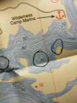
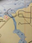
I'm now going to upload some photos from my own lake maps highlighting very key areas that would be great targets from the shoreline and maybe a few by boat..... Many fishermen will love me for pointing some of these out, others may hate me.


