Chase Simmemon
Senior Member
Got out on Lanier 12/20 to do a little fishing and playing with Lowrance's Insight Genesis program. I didn't get to stay on the water long, only about 3-4 hours, since I still had a little Christmas shopping to do, but we ended up catching around 5-6 spots in the 3-3.5 pound range and one striper that might have gone around 10 pounds. All the spots were caught drop shotting Wackem's LJ's Obession and the striper was caught on a Fish Head Spin.
But while I was out I decided to record some sonar logs and upload them to Lowrance's Insight Genesis program to see what kind of maps I could create. Insight Genesis is a super easy program to use and only takes 4 easy steps to create customized maps.
1. Record a sonar log to an SD chip using your Lowrance chartplotter
2. Upload the sonar log file using the Insight Genesis Upload tool on your computer
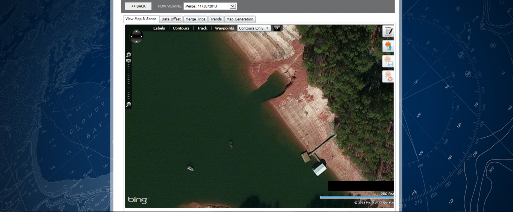
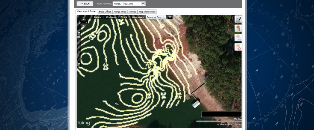
3. View your customized map for FREE
4. Download your map for use on your Lowrance chartplotter.
You can purchase a single encrypted map for use on your chartplotter or you can choose an annual Insight Genesis subscription that provides unlimited ability to download maps, store trips securely online and other customization options.
The cool thing with Insight Genesis is that you can merge different trips from different dates, so over time your maps will cover more area and become more defined. You can also choose to keep your sonar logs and maps private, so the data, including contours, depths, waypoints, routes or tracks will never be used by anyone, including Navico or other subscribers .
.
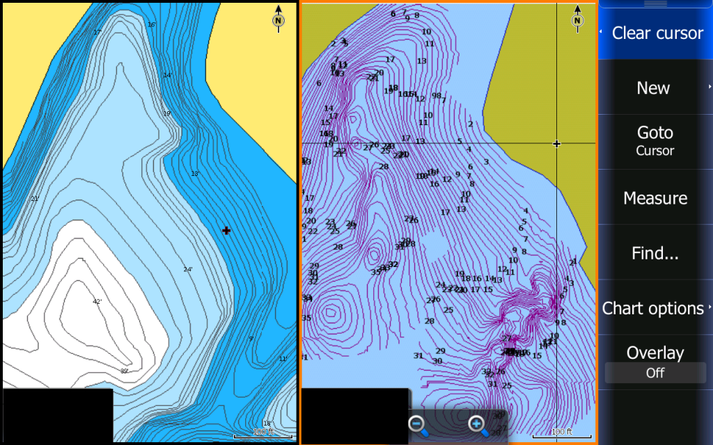
Here is an example of one of the maps that I made on Lanier. I'm sure most of you Lanier guru's know exactly where this ditch is at, so blacking out the coordinates is probably redundant, but I didn't want to make it to easy on the ones that don't know where it is at . As you can see from the pictures, the Navionics chip doesn't show the ditch on their map (they actually show it has a hump like an old road bed or pond dam), but with the map created on Insight Genesis you can clearly see the contours of the ditch
  .
.
But while I was out I decided to record some sonar logs and upload them to Lowrance's Insight Genesis program to see what kind of maps I could create. Insight Genesis is a super easy program to use and only takes 4 easy steps to create customized maps.
1. Record a sonar log to an SD chip using your Lowrance chartplotter
2. Upload the sonar log file using the Insight Genesis Upload tool on your computer
3. View your customized map for FREE
4. Download your map for use on your Lowrance chartplotter.
You can purchase a single encrypted map for use on your chartplotter or you can choose an annual Insight Genesis subscription that provides unlimited ability to download maps, store trips securely online and other customization options.
The cool thing with Insight Genesis is that you can merge different trips from different dates, so over time your maps will cover more area and become more defined. You can also choose to keep your sonar logs and maps private, so the data, including contours, depths, waypoints, routes or tracks will never be used by anyone, including Navico or other subscribers
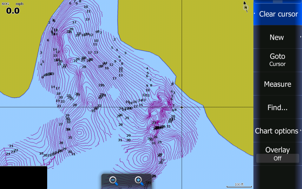
.Here is an example of one of the maps that I made on Lanier. I'm sure most of you Lanier guru's know exactly where this ditch is at, so blacking out the coordinates is probably redundant, but I didn't want to make it to easy on the ones that don't know where it is at
. As you can see from the pictures, the Navionics chip doesn't show the ditch on their map (they actually show it has a hump like an old road bed or pond dam), but with the map created on Insight Genesis you can clearly see the contours of the ditch . 


