DDD
Winter Weatherman
Alright, so there is a lot and when I say a lot, I mean a lot to talk about.
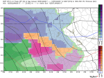
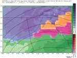
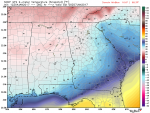
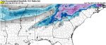
Let's talk about social media and the internet as a whole for a second. If the threat for the South East continues or develops in the coming days, social media will blow up. My twitter feed is already starting to buzz. I urge caution though buying into pictures or statements from questionable sources. People have access to all sorts of information now and will post things willy nilly. Just because a map shows 4" of snow or .75" of ice in your back yard, does not mean it's gospel. We call those maps "clown maps" for a reason. They have all sorts of colors but they are not always accurate. They are simply there to give forecasters an idea of what's happening.
Also, for the love of PETE! Please don't get on the general discussion board and say, "My weather app or The Weather Channel app says 65° and sunshine" or "The 10 day forecasts shows 50° and rain". People, there is VERY LITTLE reliability in up to date and accurate forecast with weather apps. If that is your "source" for accurate weather data, I am sorry, you haven't been paying attention.
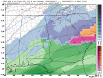
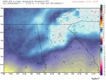
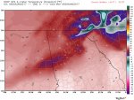
Let's get into the details. First and foremost, many METS who are much more knowledgeable than I, are talking about the "blocking" in the North East and the Upper Level Low (the storm) are causing problems run to run for models with a solution in the SE part of the United States. Basically, yes the solution could be accurate or it could be absolutely false because the model is spitting out a solution that is not really there.
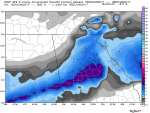
On a personal note, I am HIGHLY skeptical of the current solution put out by the GFS. Why? Because it is a MAJOR Snow and Ice storm being modeled in a La Nina winter. It could still happen and the scenario that it cranks out is one for the record books. I just don't want people getting their hopes up just to have them wiped out. You will see what I mean below.
Also, the GFS has been showing a separate storm brewing around the Monday night / Tuesday / Wednesday time frame 8-10 days out. It has modeled that threat for the last 3 runs before the 18Z came out and moved the threat up 3 days.
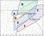
So, for now, understand that we have a threat in the near future. The details are a little foggy at this point.
Please join me over at the General Weather Discussion page for questions and thoughts.
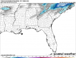
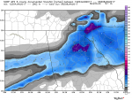
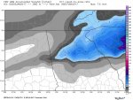
Pictures with descriptions will be posted below in separate threads.
Let's talk about social media and the internet as a whole for a second. If the threat for the South East continues or develops in the coming days, social media will blow up. My twitter feed is already starting to buzz. I urge caution though buying into pictures or statements from questionable sources. People have access to all sorts of information now and will post things willy nilly. Just because a map shows 4" of snow or .75" of ice in your back yard, does not mean it's gospel. We call those maps "clown maps" for a reason. They have all sorts of colors but they are not always accurate. They are simply there to give forecasters an idea of what's happening.
Also, for the love of PETE! Please don't get on the general discussion board and say, "My weather app or The Weather Channel app says 65° and sunshine" or "The 10 day forecasts shows 50° and rain". People, there is VERY LITTLE reliability in up to date and accurate forecast with weather apps. If that is your "source" for accurate weather data, I am sorry, you haven't been paying attention.
Let's get into the details. First and foremost, many METS who are much more knowledgeable than I, are talking about the "blocking" in the North East and the Upper Level Low (the storm) are causing problems run to run for models with a solution in the SE part of the United States. Basically, yes the solution could be accurate or it could be absolutely false because the model is spitting out a solution that is not really there.
On a personal note, I am HIGHLY skeptical of the current solution put out by the GFS. Why? Because it is a MAJOR Snow and Ice storm being modeled in a La Nina winter. It could still happen and the scenario that it cranks out is one for the record books. I just don't want people getting their hopes up just to have them wiped out. You will see what I mean below.
Also, the GFS has been showing a separate storm brewing around the Monday night / Tuesday / Wednesday time frame 8-10 days out. It has modeled that threat for the last 3 runs before the 18Z came out and moved the threat up 3 days.
So, for now, understand that we have a threat in the near future. The details are a little foggy at this point.
Please join me over at the General Weather Discussion page for questions and thoughts.
Pictures with descriptions will be posted below in separate threads.
Last edited: