***March Severe Weather Thread 2017***

Miguel Cervantes

Jedi Master
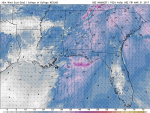
Still 9 days out, but this one bears watching. It could shape up to be a healthy severe outbreak with supercells embedded in the system. The worst would be the "midwest" but as we can see on this 3km helicity map Bama and Ga wouldn't escape some severe potential either.

This is around 8pm on Friday the 24th. Timing and prognostications are sure to change this far out.

ehi03.conus.png


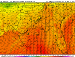
The higher up in the nation that low goes the better for us. Likewise if it takes a lower path it'll be katie bar the door.

sfcwind_mslp.conus.png
 

Miguel Cervantes

Jedi Master
Last information for March Severe Wx thread.

Temps will be well into the high 60's and low 70's when this system arrives in NW Ga around midnight tonight. Wind gust will be nearing 40 mph. Dynamics are good for severe weather overnight late Thursday into early Friday morning.

The models still don't handle CAD well, and this CAD from the Atlantic HPS will be bringing low clouds and drizzle for parts of the Northern half of our state today, keeping the humidity and dewpoint primed. By later on this afternoon the clouds should retreat to usher in the temps needed to set off the severe threat for overnight.

Y'all know the drill, ears and eye's peeled, heads on a swivel and NOAA Weather radios are your friends, and just may save your lives.

Here's a few pretty pictures for projected conditions around midnight-ish tonight.
 

Attachments

  • 033017simrad05z.png
    033017simrad05z.png
    578.2 KB · Views: 214
  • 033017windgust05z.png
    033017windgust05z.png
    842 KB · Views: 219
  • 0330172mtmps05z.png
    0330172mtmps05z.png
    559.1 KB · Views: 206
Top