Woodshound
Member
Took the day off Friday and hiked the Arkaqua trail from Track Rock Gap to Brasstown Bald. I had heard it has spectacular winter views, I've put it off for a few years, and decided to knock it out before leaves come in and I have to wait several more months.
I had also planned to hike up Chimneytop and Blue Bluff, both short bushwhacks and on the Georgia 4000 list, and so arrived at dawn at the trail head on Track Rock Gap, and set out.
The first 1.6mi goes straight uphill, with a few switchbacks begrudgingly tacked on at the end - its brutal (and I'm in decent shape). Once you get to the top of Buzzard Roost Ridge, though, it becomes more standard rolling ups and downs like you see on other ridge trails. The winter views are fantastic and they are fantastic for almost the entire trail. Some truly spectacular views of the surrounding countryside. This is also the first place where you can see the tower on Brasstown. It looks very far from here.
Also notable - from the top of the ridge down to Low Gap, the forest floor had been rototilled (in some places, intensely so) by hogs. It looked maybe a few days old? A week? I scouted around a bit to check things out - to the south, overlooking Plott Cove, its either incredibly steep or impassible bluffs. There's a lot of blue lines draining into Arkaquah Creek but it'd be hard to get up and down there from the trail. The north side of the ridge slopes more gently towards fields, but is still rough going.
After Low Gap, I went up Blue Bluff to knock this off the GA 4000. If you ever have an interest in going up, do not do what I did, which was to bushwhack in from the west. It looks reasonable on topo but halfway up it becomes waves of boulders covered in moss, fenced in with rhodo. Instead, walk past Blue Bluff on the trail and go up the shoulder of the much nicer eastern ridge , where you will see a manway has been trodden down (at the spot on the trail nearest N34 52'26.5" / W83 50'23.0", walk uphill ten feet and look west/right). There's a rock cairn at the top and decent winter views.
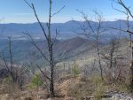
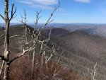
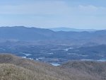
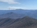
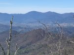
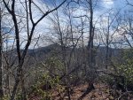
Chimneytop was next. I found instructions from a few years ago to get to the Chimneytop unobstructed views by walking through the remains of the burn from the Chimneytop Fire. This works to get to a magnificent view - one of the best I've seen in the mountains - but the brush up there has recovered well and is growing back with a vengeance (and if you thought regular rhodo was bad, burned rhodo is its own special awful). There are thick canes, dense brush, deep moss that (as of Friday) require a machete to get to the high point slabs. However, just getting to the rocks in the burn is worth it. I will say, the approach is a climb over warm rocks with lots of cracks and crevices and feels pretty snakey. It was a bit early on Fri, but I'll bet you this place crawls later in the year.
I was disappointed that I couldn't get to the west chimneytop high point... and then immediately past the burn is a beautiful and obvious manway that takes you up there. I went up, hit the point, went to the higher crag and enjoyed those views, and walked back down. There was coyote scat on the rock faces.
Closer to the brasstown parking lot, there's a section of the trail that was damp, moist, and muddy. And full of hog prints. I stopped to get my bearings: Bald Creek has three little rivulets - the easternmost starts at the Brasstown Bald Parking area. I was standing just north of the westernmost rivulet (the center rivulet actually crosses the trail further east, but there was no hog sign there). Down the hill I went, scoping out the area - I found another hog print in a muddy dip about 50 yards down, so I suspect they came up that direction, but I was already exhausted and slightly behind the schedule I had set myself, so I moved on.
There were ten cars in the Brasstown parking lot. I saw two other groups of people on top. Air was clear and the views were fantastic. I saw three people on Arkaquah ... took 4.5hrs to get up, with extra bushwhacks and a bunch of time taking in the views from Chimneytop. 2.5 to get down.
Attached pics are from Chimneytop.
Anyone ever hunt the Brasstown wilderness (I found one thread here from a few years ago)? This is some rough country but I'm curious as to how far the hogs move around in here and if anyone's taken one ... I am going to check back in here next time I'm around. Its a brief hike down from the Brasstown parking area to the Bald Creek stretch of trail and now I'm kinda curious about it.
I had also planned to hike up Chimneytop and Blue Bluff, both short bushwhacks and on the Georgia 4000 list, and so arrived at dawn at the trail head on Track Rock Gap, and set out.
The first 1.6mi goes straight uphill, with a few switchbacks begrudgingly tacked on at the end - its brutal (and I'm in decent shape). Once you get to the top of Buzzard Roost Ridge, though, it becomes more standard rolling ups and downs like you see on other ridge trails. The winter views are fantastic and they are fantastic for almost the entire trail. Some truly spectacular views of the surrounding countryside. This is also the first place where you can see the tower on Brasstown. It looks very far from here.
Also notable - from the top of the ridge down to Low Gap, the forest floor had been rototilled (in some places, intensely so) by hogs. It looked maybe a few days old? A week? I scouted around a bit to check things out - to the south, overlooking Plott Cove, its either incredibly steep or impassible bluffs. There's a lot of blue lines draining into Arkaquah Creek but it'd be hard to get up and down there from the trail. The north side of the ridge slopes more gently towards fields, but is still rough going.
After Low Gap, I went up Blue Bluff to knock this off the GA 4000. If you ever have an interest in going up, do not do what I did, which was to bushwhack in from the west. It looks reasonable on topo but halfway up it becomes waves of boulders covered in moss, fenced in with rhodo. Instead, walk past Blue Bluff on the trail and go up the shoulder of the much nicer eastern ridge , where you will see a manway has been trodden down (at the spot on the trail nearest N34 52'26.5" / W83 50'23.0", walk uphill ten feet and look west/right). There's a rock cairn at the top and decent winter views.
Chimneytop was next. I found instructions from a few years ago to get to the Chimneytop unobstructed views by walking through the remains of the burn from the Chimneytop Fire. This works to get to a magnificent view - one of the best I've seen in the mountains - but the brush up there has recovered well and is growing back with a vengeance (and if you thought regular rhodo was bad, burned rhodo is its own special awful). There are thick canes, dense brush, deep moss that (as of Friday) require a machete to get to the high point slabs. However, just getting to the rocks in the burn is worth it. I will say, the approach is a climb over warm rocks with lots of cracks and crevices and feels pretty snakey. It was a bit early on Fri, but I'll bet you this place crawls later in the year.
I was disappointed that I couldn't get to the west chimneytop high point... and then immediately past the burn is a beautiful and obvious manway that takes you up there. I went up, hit the point, went to the higher crag and enjoyed those views, and walked back down. There was coyote scat on the rock faces.
Closer to the brasstown parking lot, there's a section of the trail that was damp, moist, and muddy. And full of hog prints. I stopped to get my bearings: Bald Creek has three little rivulets - the easternmost starts at the Brasstown Bald Parking area. I was standing just north of the westernmost rivulet (the center rivulet actually crosses the trail further east, but there was no hog sign there). Down the hill I went, scoping out the area - I found another hog print in a muddy dip about 50 yards down, so I suspect they came up that direction, but I was already exhausted and slightly behind the schedule I had set myself, so I moved on.
There were ten cars in the Brasstown parking lot. I saw two other groups of people on top. Air was clear and the views were fantastic. I saw three people on Arkaquah ... took 4.5hrs to get up, with extra bushwhacks and a bunch of time taking in the views from Chimneytop. 2.5 to get down.
Attached pics are from Chimneytop.
Anyone ever hunt the Brasstown wilderness (I found one thread here from a few years ago)? This is some rough country but I'm curious as to how far the hogs move around in here and if anyone's taken one ... I am going to check back in here next time I'm around. Its a brief hike down from the Brasstown parking area to the Bald Creek stretch of trail and now I'm kinda curious about it.