Bananaslug22
Senior Member
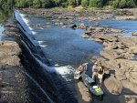
5 or so of us put in at Langdale and floated down to Crowhop ahead of the scheduled generation. Got to Crowhop 20 minutes before the water did. 6 fish caught between the 5 of us and 4 of those were on the way down to Crowhop! I got skunked. Dad got skunked. One guy caught 3, and then 1, 1 and 1.
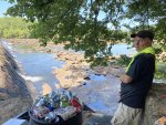
First time getting Dad on a kayak. He was a little worried but came away highly impressed with what they can do. Cant wait to get him on the Flint for some Shoalies. This was the first time he'd been to Crowhop in 57 years. His dad took him down there as a 7 yr old and per Dad, this is where he caught his first fish over off the sandy beach in the background of the photos on the Georgia side.
He said they went through 300 ft long mud holes in his dad's 63 Ford along the old logging roads that are not doubt still there. Glad he got to see the dam again before they get torn out.
Get down there to Langdale and Crowhop while you can fellas. Once they're gone, they're gone!