Bushwhacking to waterfalls

Woodshound

Member
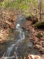
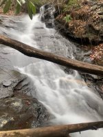
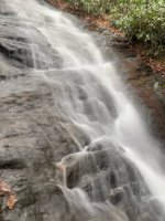
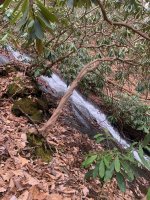
Took advantage of the Season of the Dead Understory to get out and put eyes on some features I desk-explored via topos last year. I went looking for one thing and didn't find it; but as it so often goes, found something else: remote waterfalls. I don't think they're "discovered" which in our time means "documented clearly on the Internet for all of instagram to go find", not even the waterfall hunting websites (at least the ones I know about). They are only sensibly accessible during winter - and even now are still a tricky bushwhack.

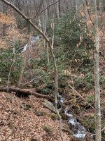
I ran out of time this weekend but will be headed back out again soon - hopefully after another big rainfall - to do some more exploring in this particular part of the wilderness. Having gotten eyes on it, I'm pretty sure there's another, bigger falls out here and I want to get higher up in a few places and look around.
 

Attachments

  • image0.jpeg
    image0.jpeg
    246.4 KB · Views: 81
  • image1.jpeg
    image1.jpeg
    280.5 KB · Views: 79
  • image2.jpeg
    image2.jpeg
    209.6 KB · Views: 78
  • image3.jpeg
    image3.jpeg
    145.4 KB · Views: 78
  • image4.jpeg
    image4.jpeg
    492.6 KB · Views: 77
  • image5.jpeg
    image5.jpeg
    438.5 KB · Views: 78

1eyefishing

...just joking, seriously.
(y)

'Ear Falls'.
On Cochrans Creek above Cochrans Falls along the nothern toute in.
Long before the Len Foote Inn or the trail to the Inn.

earfall.jpg
I can't put my finger on the polaroids from the top of Cochrans Falls.
:(
 

Woodshound

Member
Sweet falls! That's fantastic ... I went to see Cochran from the top a few years ago from the Hike Inn trail. Going in from Springer Mountain back in the day must have been a real nice bushwhack :)

On the way back out, I was stumbling, cut up a bit, muttering to myself and emerged from the trees as a troop of girl scouts were arriving at the Hike Inn - they started panicking and crying out. Troop leader later told me they had been ramping each other with scary stories about wild men, bigfoot, and so on in the woods and when I came crashing through the underbrush it was apparently the stuff of nightmares.
 

1eyefishing

...just joking, seriously.
20230109_113321.jpg
20230109_113258.jpg


I made it down the eastern flank to the bottom, but swore not to try it again without ropes.
Falls to the left...
Bwhacked back up and out the western flank.

20230109_113244.jpg

There has been at least one death there since the eighties, At least one helicopter rescue, and an incident where rescuers had to be rescued by a second team.
 

Woodshound

Member
You went down from the top and back up?! I was alone and short on time, so chose to take a little bit longer at the top and then head back.

Had no idea about the rescues and deaths but I'm not surprised at all - one wrong step and that's a long, long fall. Or worse, half of a long fall and you're clinging to the side.
 

dwhee87

GON Political Forum Scientific Studies Poster
I did the hike most of the way up Cochran Falls last spring. I was on the 'trail', which involved a fair bit of bushwhacking. We stopped where the old looking rope was tied up a sloped, moss-covered, wet rock, and decided that was far enough. Looking at the topo map, we still had another 300 or so feet in elevation to go to get to the top.
 

1eyefishing

...just joking, seriously.
This is a relatively unknown twin sister of Amicalola falls.
A spring off the same mountain and falling off virtually the same ledge. Separated by a big ridge in the Amicalola state park.
I think the trail from the bottom stops at a lower falls. There was no kind of trail along either side where I was. Looks like about 700' higher. And a little more than a quarter mile further in...
Beautiful area.

Screenshot_20230109_155808_onX Hunt.jpg
 

1eyefishing

...just joking, seriously.
Beware the western flank.
I recut a long staff with a good hook near the handle and was hooking brush above me and pulling myself up and then passing the hook back down to my girl who used it to come up behind me 6 or 7 feet at a time. The Eastern flank isn't quite as tough but very dangerous with slippery narrow wet leaf covered path with a long fall possible.
I would suggest knowledge of self belay techniques, leaving one rope in place near the top and working off a second rope further down.
Partner and hiking plan. Cellphone communications were not a thing back in '94 but still would doubt very good service in there.
It would be worth bumping this thread or starting a new one when you go!
Safety first and good luck!
 

ripplerider

Senior Member
Now this is a subject near to my heart! I spend a lot of time and energy poring over topo maps and bushwhacking in to likely waterfall areas. I dont believe in posting directions and GPS coordinates on-line so the less-motivated folks can follow their Garmins right to them. I dont want to see a bunch of trash or people there the next time I go in. Or red flagging if some "directionally challenged" folks want to help the next bunch find it. I'll warn you, there are people on-line who will tell the world about something you shared with them. Their only into this hobby for the glory of being the first to document a falls on the internet. I know, I've had it happen to me and I've talked to a guy who spends a lot of time in the Cohutta backcountry. Same guy did him like that. I shuttle hikers on the AT for a living so sometimes I have time on my hands between trips. I'm already in a remote place; why not scout for waterfalls? I particularly love to hit a small high branch after a big rain and see whats up there. It may only be worthwhile to photograph a few days a year but that just makes it more special.
 
Last edited:

1eyefishing

...just joking, seriously.
Good thing we dint post directions or coordinates to a place with plenty of stories/info already on the internet.
Even though this forum is made for discussing/sharing.
 

ripplerider

Senior Member
I wasnt referring to your posts sir. Cochrans falls are pretty well known, though very much off the beaten path. There are no falls of that size left undiscovered in Georgia. But there's lot's of small branches with undocumented waterfalls on them that are just too much trouble for most folks to explore. Again. I meant no harm. Just a word to the wise about posting locations on the internet. Take it or leave it.
 

ripplerider

Senior Member
We can discuss and share pics without putting a gps coordinate on everything cant we? I sure hope so cause I'm outta here if not.
 
Top