Sorry bilgerat. Go to noaa.gov and follow the trail of links to the marine navigation section. I did a cut and paste from a link in a 3 year old email. I guess it changed.
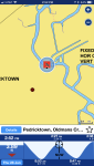
Depending on your need, you might try the below. To print, I have found using 'portrait' distorts the image, if I use 'landscape' it does not seem to do so. It carries the notation to "not use for navigation".
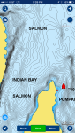
The pink/purple birds/ducks indicate different types of marine sanctuaries or estuary area zones/nature reserve areas. These can be environmentally sensitive sea areas or areas with minor restrictions and/or information notices.
As mentioned above, the Navionics WebApp is about as good as it gets for free maps, however, I would highly recommend getting the Mobile App for your smartphone because it is an unbelievable value and has a ton of features on top of the fact that it has the best maps out there.