bullgator
Senior Member
This is weather. Let me know when anyone can predict it with 100% certainty.
Let's stay with the topic and out of political opinion.Pretty sure that's the identical logic used to shut down the country during the pandemic and mandate the vaccine.

This is weather. Let me know when anyone can predict it with 100% certainty.
"Operational practices at the National Hurricane Center (NHC) have varied over time; in recent years surface winds have typically been taken to be 80%–90% of the flight-level wind. This practice was motivated largely by the assumption that strong convective motions in the hurricane eyewall would be particularly effective at transporting high-momentum air to the surface layer. Use of these relatively high ratios has periodically resulted in criticism of NHC intensity estimates."
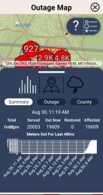
Regardless...TriCounty Elec Co op reporting 99% outage in their service area, which the track has dissected. I'll weigh in a week from now on over reaction...
View attachment 1251259
That's good!
I guess you didn't read the post before yours. We're discussing reported measured readings vs actual measured readings.Could it be because the guestimate is more scary than the actual readings?
TruthFrom a first responder perspective, I’m glad things shut down. Less people being stupid trying to get to town and driving through high water and such. Lots of folks make bad decisions on good days, seem to make worse decisions during bad weather.
Power outages are often more indicative of infrastructure and how well it is maintained than wind speed. A big chunk of eastern Liberty County was off line for several days, just a few years ago, after a thunderstorm with max wind gusts of under 50 miles an hour. The same area was powerless for over a week when Hurricane Matthew went by offshore, because trees took out a massive number of transformers, lines and poles. Yet the recorded max winds never topped 50 mph.
In St Marys (except for downtown where the usual flooding interrupted power) the power never went out during Matthew, even though they saw sustained winds of near 65 mph.
I guess you didn't read the post before yours. We're discussing reported measured readings vs actual measured readings.
Nothing to do with guestimates, predictions, prognostications, etc.
Hate to hear that.16 deaths being reported thus forth, reported to be storm surge related.
Well when you come acustom to a certain lifestyleThats sounds like a serious case of first world problems!
Congratulations on putting together this insightful analysis. You do also realize that it is just as possible that the weather bouy in question was erroneously reporting wind speed? There were only about fifty hurricane hunter flights in and around the storm leading up to landfall; all of which were measuring wind speed among other parameters. Also, dopler radar from multiple locations would be useful in fairly accurate estimations of conditions.The "overreaction" might be a response to the official exaggeration.
For instance: At about 7:00 am this morning Idalia crossed the coast almost on top of an automated NOAA weather data recording station. The NOAA/National Hurricane Center (NHC) proclaimed that Idalia was a Category 3 "Major hurricane" (sustained winds of 96-112 knots) at the time. Their OWN weather station, right there where the storm came ashore, recorded MAXIMUM sustained winds for that period of 53 knots (tropical storm strength, below the minimum of 64 knots to be classified as a hurricane). The NOAA station is KTNF1, Keaton Beach, FL.
About an hour before landfall NHC had classed the storm as a Category 4 Major Hurricane (sustained winds 113 to 136 knots). In the immediate area of the eyewall was another NOAA Weather Buoy (NOAA station 42036). That buoy recorded maximum sustained winds under 50 knots and a maximum gust of 60.3 knots over the past 24 hours.
If you are in the path of a hurricane that is officially STILL a hurricane FOUR hours after it crossed over onto land, you might want to close shop too! On the other hand, if the storm is causing a lot of rain and winds up to 35 miles an hour (like reported by NOAA station VAT in Valdosta, GA with the storm right there), maybe you would remain open!
Do I need to buy a bigger tinfoil hat?